
Maps and Information
I have information on Mississippi River mile markers and how long it took me to paddle from point to point here;
Please see the many questions and answers about my Mississippi River trip on my blog. Please ask new questions below.
The Minnesota DNR has lots of information about the upper river, including maps and other information.
The Army Corps of Engineers has excellent navigational charts for the river from Minneapolis to Cairo and for the lower river below Cairo. You should be able to download and print maps from them if you like, although you might have to search around to actually find them. If I were to do the river again I would plan on carrying a mapping GPS AND download maps to a smartphone and forgo the Corp of Engineers maps completely.
A good source for information and other links is the Mississippi River Resource Page.
A very well-written book on canoeing the Mississippi is “Mississippi Solo.” The only disappointment is he skipped some sections of the river. Nevertheless, the book is well worth it for the writing itself and his keen observations of the people along the river.
Some facts collected on the Mississippi National River and Recreation Area page:
A raindrop falling in Lake Itasca would arrive at the Gulf of Mexico in about 90 days.
Average river speed at headwaters: 1.2 miles per hour.
River speed at New Orleans on 2/24/2003 was 3 miles an hour.
River length, about 2,350 miles.
Narrowest point: about 20 feet, just below Lake Itasca.
Widest point: about 4 miles at Lake Onalaska near LaCrosse, Wisconsin.
Shallowest point: just below Lake Itasca, less than 3′ deep. (I found the river to be less than 6″ deep in places in that area.)
Deepest point: about 200′ at New Orleans.
Elevation above sea level at Lake Itasca: 1,475 feet.
Elevation above sea level at the Gulf of Mexico: 0 feet. More than half of the total drop of the river occurs in Minnesota.
The Mississippi River drains 41% of the continental United States.
How long will it take?
It took me 67 days, by myself, under what is probably fairly typical water conditions. Some people might want to take four months or more. Really fast people might be able to do it in less than two months. If you don’t know how fast of a paddler you are, I’d allow at least 3 months. The river’s speed depends a lot on water levels. You may find the current much faster or slower than I did. Your trip will likely NOT be the Huck Finn experience many envision, where you simply sit and watch the world go by. I paddled most of the day from before sunrise until just before sunset. Most folks will want more time off and shorter paddling days. On my trip, the current was perhaps 1.5 miles an hour, average, above St. Louis, and 3.5 mph from there to Baton Rouge. Below there, it slowed down somewhat again.
When should I start?
Much will depend on your pacing. On my rather fast trip I started in mid-August and that was a good choice for me. The ice in northern Minnesota can melt very slowly and on some years may last well into May, so make sure you don’t start too early in the year. I’ve read at least two reports of people who started in September and they found it got too late in the year and too cold by the time they finished.
Can beginners do the Mississippi River?
Good judgment is a must for doing the river regardless of skill level. Some boating and camping experience is necessary to do the river safely. You shouldn’t be learning how to paddle your canoe on the river, especially if you’re starting at Lake Itasca. On the other hand, you don’t need to be a whitewater paddling expert. You should know how to pick safe camp spots (anticipate rising water,) how to keep yourself and your gear dry, etc. So I would say that beginners probably shouldn’t tackle the river unless they are with more experienced people. On the other hand a level headed person who is merely competent in boating and camping should do fine.
How much will it cost?
That is a very subjective question. It could cost you thousands, or only a few hundred. My biggest expenses were flying back home from New Orleans, two nights in a motel waiting for my flight, and shipping my canoe back home, which cost about $300 itself. I think I probably only spent about $10 a day while traveling down the river. I camped every night and ate regular grocery store food (no freeze dried foods.) It would be possible to spend much, much more, by eating meals in towns, spending lots of time in motels, eating out, and hanging out in bars. One reason I stayed out of towns except for grocery/water stops is that I didn’t want to leave my canoe for too long.
Where did you get food and water?
I didn’t have a guidebook or anything, so I just looked at my maps and watched for towns, and asked people along the way. I probably got food every four or five days. You could get food much more often, or much less often. At these stops, I’d hide my canoe and/or chain it up, and bring my most valuable items with me.
Will I have trouble with locals?
I think you pretty much make your own luck here. If you hit the bars and camp in sight of the boat landing, you may have trouble. I had no trouble at all. Choose your campspots wisely. “Out-of-sight, out-of-mind” is something to think about. If no one knows you’re there, you’re far less likely to have trouble. If you have to leave your boat, a boat that is both perfectly hidden AND locked up is far less likely to disappear.
Will the bears get me?
Don’t keep food in your tent, and bears are HIGHLY unlikely to hassle you. I saw only one, as it swam across the upper Mississippi, and it ran as soon as it hit shore.
How about food?
I found food, water, and other supplies relatively easy to get along the river in most stretches. Just plan ahead.
Will the big boats destroy me? They will if you don’t pay attention. Below Minneapolis/St. Paul, where the lock and dam system starts, the navigation channel is marked by red and green buoys. You should be especially aware whenever crossing the river through this main channel and when approaching bends in the river. It is usually safer to take the inside bend than the outside bend because you are more likely to stay out of the deep-water channel, and you’ll be less susceptible to the huge wakes thrown off by towboats rounding the bend. It is very difficult for the big ships and rafts of barges to maneuver, so you should always assume that they don’t see you and will run you down if you don’t watch out for yourself. I had no close calls with boats, and did not find it too stressful avoiding them.
It may come as no surprise that the biggest danger on the Mississippi is the river itself. Don’t mix alcohol and boating, and always wear your life jacket out on the water. When you load your canoe, secure your gear as if you expect to capsize during the day. Be especially careful if the water is cold.
Here’s some good words of advice from the Corp of Engineers…
Avoid dangerous currents found immediately above and below all navigation dams.
Stay clear of barges and towboats. The cannot stop or maneuver easily, and can create dangerous currents even when tied up.
Be cautious of wingdams and other submerged structures outside of the nine foot channel. Not all hazards show up on the chart.
Learn proper locking procedures.
To add to what the Corp said, one of the biggest dangers on the Mississippi River or any fast moving body of water are currents near fixed objects. Where the water is fast, steer clear of moored barges or boats, steep banks, wingdams, trees or anything else that can create dangerous currents. They are far more powerful than the strongest paddlers and can easily trap you and destroy your boat.
How will I get home?
If you plan on canoeing most of the river, you have several choices as to where to end your trip. Here they are, in order, from north to south:
Atchafalaya River is a “distributary” of the Mississippi River. Some people choose it because it’s a shorter and wilder route, missing New Orleans and Baton Rouge altogether.
New Orleans Many people stop at New Orleans. That’s the easiest place to end your trip, with readily available transportation, and many people consider it the end of the river for all practical purposes.
Venice, Louisiana is the last town along the road system. You might decide to have friends or family pick you up there. I actually found it fairly easy to hitch a ride for me and my canoe up to New Orleans from Venice, once people knew I had canoed the length of the river.
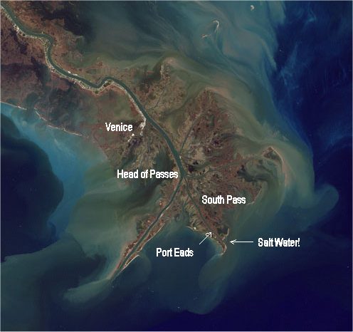
Mile Marker “0” (Head of Passes) is symbolically the end of the main Mississippi River because after that point the river branches out into several channels: Southwest Pass, South Pass, and Pass a Loutre. This point is several miles downriver from Venice. The mile marker was pretty obvious, at least when I was there. It would be hard work, but possible, to canoe from this point back to Venice, if you pick the slowest current and take advantage of eddies. It should also be pretty easy to “hitch” a ride back to Venice with a passing fishing boat.
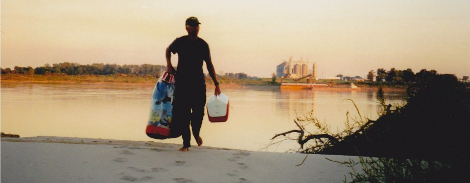
The Gulf of Mexico at one of the outlets of the Mississippi. Southwest Pass is the main shipping channel. I chose South Pass. South Pass is the center channel at Mile Marker “0”. I didn’t have a map when I got there, so I remember hanging on the a big pile in the strong current so I could ask a passing boat to verify which one was South Pass. The boat traffic was fairly tame in South Pass, and mostly consisted of fishing boats. I was offered a place to stay on my last night, at South Pass Marina, (Port Eads.) The salt water is only about two miles below Port Eads, and it was an amazing sight. It would be hard work, but possible, to canoe from this point back to Venice, if you pick the slowest current and take advantage of eddies. What I did is canoe from the salt water back to Port Eads, then I got a boat ride from there to Venice. It should be easy to “hitch” a ride back to Venice on a fishing boat. For most folks, the cheapest and best option for getting home from Venice or New Orleans will be a ride from friends or relatives. It cost me $300 to ship the canoe. (It was borrowed.) I flew home and mailed my paddles. I simply taped them together, and put my address on a paddle blade then took them to the Post Office! It worked great. I know of people who have given away their canoes at the end of the trip.
Note, I do not know how hurricane damage has changed the river below New Orleans. If someone can tell me, I’ll post an update.
Below is an amazing NASA satellite image of the mouth of the Missississippi River. You can see the road to Venice running down the west side of the river and ending about mid-photo. You can also see the river branching out at Head of Passes at Mile Marker “0.”
What will I need to bring?
I had some trouble figuring out what type of canoe would work best. It seemed that most folks who’d canoed the river had just used whatever canoe was at hand. Now that I’ve made the trip, I’d suggest making stability your number one consideration. I never flipped the canoe once, and part of that was because of the design of the canoe I borrowed from my friend Gerry Molberg. It was a standard 17′ Alumacraft, weighing about 65 lbs. Kayaks might be an even better choice for many people.
I found that for packing purposes it was best to think of the river in two parts; before the Twin Cities (above which there are a dozen or so portages,) and after, where the only portaging you are likely to do is around busy locks. (At some locks, you may only have to portage as little as 30 feet!) After the Twin Cities, you may want to consider adding an ice cooler, and even a lawn chair.
- Two good paddles: One I borrowed. The other I bought from canoeing experts who helped me select a good fit for me. I chose a canoe paddle with a “bent” shaft
, which is supposed to increase efficiency, and I believe it did.
- Dry Bags: Two of them to protect my most vital gear. You will get rained on a lot, and often your gear will be sitting in water sloshing around the bottom of your boat. Plan accordingly! I like the NRS Bill’s Bag
- Life Vest
- Cooler: I’d suggest on holding off on the cooler until you’ve reached the Twin Cities. There are lots of portages before then!
- Rope: About 20′ long, for securing your canoe every time you land. Tie good knots, and check them frequently.
- Chain and lock: I only had to use this a couple of times. The trouble is, if you leave your canoe you also are leaving most of your other stuff.
- Giant Sponge: For soaking up that water that will be sloshing around your canoe. Also works good for mopping up sand and silt.
- Plastic Box: Once I got past the portages, I bought a large, clear plastic box with a tight-sealing cover. It worked great as a bombproof, waterproof container.
- Tarp
- Tent/Poles/Stakes: Get a good one and be very selective on where you set it up. Stay well above the water and out of poison ivy. Try to camp where people won’t see you.
- Sleeping Bag
- Sheet: For those hot nights when your bag is too hot.
- Sleeping Pad
- Pack: for toting your groceries and drinking water back to the river.
- Stove/Fuel: bring a small, simple one. Often you can’t or shouldn’t, build a fire. If you don’t already own a stove, consider a Multi-fuel stove
which will burn gasoline or white gas.
- Water filter
- Water Containers: About 3 gallons worth of storage for each person Several smaller ones are better than one giant one. An expandable water carrier
will be a good choice for many people. - Matches and lighter: Several sets, secured in dry spots
- Food: You can pick up food every couple of days or so along the river. After the Appalachian Trail, I delighted in carrying lots of heavy and/or fresh foods.
- Cooking pots: One big and one small
- Knife, fork, spoon
- Garbage bags: heavyweight, large, several
- Ziplocks: Lots. Freezer style, 1 quart and one gallon zipper type
- Mapping GPS
- If I do the river again I’d bring a Smart phone
- Solar Charger: I kept my iPhone charged for months with a sCharger-5
Make sure it’s compatible with your phone.
- Binoculars
- Camera and batteries. I’d just use my iPhone.
- Duct Tape: Bring 30 feet or so, perhaps wrapped around your water bottle.
- Pocket Knife: The Swiss Army knife
- Multi-tool
- Parachute cord: 100 feet
- Radio and batteries: For news, tunes, weather
- LED Headlamp
- Compass
- River Maps
- Watch with alarm. Optional if you have a phone.
- Phone Card. If you don’t have a phone.
- Credit Card
- Driver’s License
- Cash
- Weather radio. If you don’t have a smart phone.
- Marine radio
- Mug
- Pens
- Notebook, diary: I carried a mini tape-recorder on this trip to serve as a journal.
- Books: Try “Huckleberry Finn,” “Life on the Mississippi,” and “Tom Sawyer”
- Address Book. Forego if you have a smart phone.
- Good Rain jacket
Make sure it has a hood. You will get rained on a lot. Probably.
- Rain Pants
- Fleece jacket
- Long underwear tops and bottoms. Inexpensive Polypropylene
- Balaclava
- Shorts
- Covertible pants
- Running shoes
- Teva-type shoes
- Rubber boots: I didn’t have them and didn’t need them, but it was warm when I was on the river and many people want them, especially if it’s getting chilly on the river.
- Socks: Actually, I rarely wore socks OR shoes out on the river
- Underwear
- T-shirts
- Fleece gloves
- Sun hat
- Bandana
- Toilet Paper
- Towel
- Toothbrush/Paste
- Bug Dope. DEET based.
- Sunscreen
- Shampoo
- Razor
- Prescriptions
- Soap
- Blistex
- Ibuprofen
- Floss
- Needle: Use floss for thread
- Towel
- Fishing gear: I didn’t bring any, personally. If you plan to fish the whole way you’ll probably need a series of fishing licenses.
- First aid kit
- Other medications
“German Tourist” aka Christine has some good advice about kayaking the Mississippi on her blog.
“Buck30” has a page of lessons learned on his Mississippi trip.

Buck,
My buddy and I are hitting the river on may 1st. How should I make sure that the ice is melted in the headwaters?
Kyle
Winter often stays late in northern Minnesota. This year there will still be ice in some of the lakes the river runs through May 1, and beyond. It’s very wintery there right now in mid-April. I think Itasca State Park or Bemidji fishing guides would be good sources of information on when the river and lakes will be clear of ice.
Hi!
Thanks for the tips! I’m gonna hit the Mississippi in the spring from source to sea 🙂
-Lenny
Hi Lenny,
You’re welcome. Make sure the ice is melted in the headwaters!
Have a great trip.
Buck